'Dinosaur footprints' on Mars? NASA's Curiosity rover investigates strange rock formation on the planet

NASA's Curiosity rover is currently examining a distinctive rock formation on Mars that, to some, bears a striking resemblance to a "dinosaur footprint." This intriguing discovery highlights the diverse and often unexpected geological features found across the Martian landscape, continually offering new puzzles for scientists to solve, according to NASA.

The rover recently completed a successful maneuver, positioning itself approximately 35 feet from a three-foot-high ridge. This ridge marks the eastern boundary of a feature informally designated “Volcán Peña Blanca.” Initial orbital images hinted at its intrigue, but ground-level photographs from Curiosity provided much greater detail, prompting the mission team to prioritize a closer investigation. Scientists are particularly interested in the clear sedimentary structures visible along the ridge face. These formations could offer crucial insights into the depositional environment of the surrounding boxwork-bearing terrain, potentially revealing whether the rocks originated from ancient dunes, rivers, or lakes. The rover executed a sharp turn to approach a selected area of the ridge for detailed study.
Among the light-toned rocks currently under scrutiny is one the team has evocatively named “Huellas de Dinosaurios” (Dinosaur Footprints). The rock will undergo thorough analysis using the Alpha Particle X-ray Spectrometer (APXS), Mars Hand Lens Imager (MAHLI), and Chemistry and Camera (ChemCam) instruments. Additionally, activities include ChemCam-only targets on a typical bedrock sample named "Amboro," and pebbles dubbed "Tunari." Mastcam will capture a high-resolution mosaic of “Volcán Peña Blanca,” along with nearby rocks named "Laguna Verde," a small light-colored rock called "Suruto," and various ground patterns. The comprehensive plan also includes two ChemCam RMI mosaics of features in the distant Mishe okwa face and ongoing environmental monitoring, ensuring a detailed study of this fascinating Martian terrain.
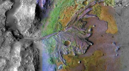
Adding to our understanding of the Red Planet's dynamic surface, the European Space Agency's Mars Express orbiter has recently unveiled a stunning new perspective of the Martian landscape. The imagery reveals a vibrant palette of yellows, oranges, and deep reds across the Arcadia Planitia region. This latest data not only showcases the planet's varied geological characteristics but also provides compelling evidence of active atmospheric processes and hints at the potential for near-surface water ice.

Captured by the Mars Express High Resolution Stereo Camera (HRSC), the newly released images focus on the eastern expanses of Arcadia Planitia. This area is strategically located northwest of the immense Tharsis volcanic province and is of significant scientific interest. This relatively flat terrain, primarily composed of ancient, solidified lava flows, is considered a prime target for future Martian missions due to the suspected presence of accessible water ice beneath its surface.

A prominent feature in the captured scene is a persuasive atmospheric haze. While appearing to obscure the view subtly, this haze serves as a clear indicator of the continuous movement of fine particles driven by Martian winds. This phenomenon underscores the crucial role wind plays in constantly reshaping the planet's topography. These streamlined rocky ridges, which Mars Express has observed previously, are sculpted by wind-driven sand and dust over vast periods. These parallel, scratch-like formations are clustered near a distinct curved boundary that bisects the image, providing further clues about the planet's geological evolution.